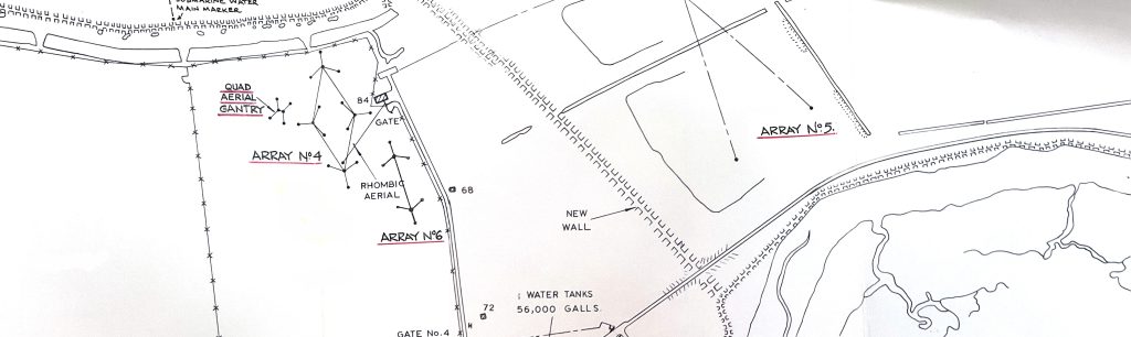
Part of a 1960s map showing a few of the many aerials on Orford Ness.
© The National Archives of the UK (TNA): ES 29/6 via Anne Mallaband. Contains public sector information licensed under the Open Government Licence v3.0
Orford Ness has been involved in radio direction finding in the inter-war period, (see the IRGON page on the Black Beacon) and the development of radar prior to World War 2. In the Cold War period, IRGON believes that Orford Ness was the location for at least three different over-the-horizon radars (OTHR) systems. These were an AWRE developed system for nuclear detonation (and possibly missile launch) detection which operated in 1960, a US developed system for the same purposes (the AFTAC R system) which operated in the mid-1960s, and a very large UK/US system (COBRA MIST) which was installed in the 1970s.
OTHR and ELINT
OTHR stands for Over The Horizon Radar, and ELINT stands for ELectronic INTelligence. The Orford Ness OTHR applications seems to have been mostly ELINT.
Why Orford Ness?
Several factors contributed to the fact that Orford Ness was home to several intelligence gathering radar systems during the Cold War era. These factors were:
- Secure location. As a military research establishment on a shingle spit, Orford Ness has had restricted public access from the beginning, and with the establishment of the AWRE facility a separate secure area was established.
- Geographical situation. Being able to “look out” towards the USSR with an unobstructed path to the sea horizon was a very important factor. 1
- Radio quiet zone. Distant from major population centres, Orford Ness was located in a quiet radio environment. 2
- Ground conductivity. Maintaining a suitable earth potential in relation to the aerial systems is important for sensitive radio and radar installations. Steel mesh earth mats can (and were) installed but high ground conductivity is an important advantage. 1
Besides over-the -horizon radar, there were other radio experiments on Orford Ness. One specific example is the radio tracking of Sputnik I, which was carried out by an AWRE team in 1957. IRGON is researching this, as well as other mysterious aerials which were present on the Ness in the 1950s and 1960s.
IRGON research continues in the field of radio and radar on Orford Ness.
The 1920s radio navigational aid known as the Black Beacon.
The first OTHR system we are aware of on the Ness, used for atomic explosion detection.
The US-supplied R system, also used for atomic explosion detection
The last OTHR system on the Ness, the ill-fated COBRA MIST.
Not on the Ness
Radio experiments of various kinds are well-known to have taken place on Orford Ness, spanning much of the 20th century. These include the Black Beacon (a large rotating loop installed in 1929 for navigation investigations); Watson-Watt’s early radar development work prior to WW2; AWRE’s successful attempts to detect atmospheric nuclear explosions in 1960; and the later ill-fated Cobra Mist Over-the-Horizon radar. However, when a 1921 reference 3 to “Orfordness W/T Station” was discovered, this initially appeared to pre-date all the other work.
Subsequent research indicated that although referred to as “Orfordness” in a few places, the station was usually called just “Orford” (without the Ness) 4, 5, 6 perhaps suggesting that it was actually on the mainland. The question was eventually resolved when a list of the wireless shore stations and their precise locations was found 7. Although even called “Orfordness D.F.” here (call sign BXH), its latitude and longitude placed it in a field around 400m to the south of Raydon Hall on the outskirts of Orford village. Indeed on the 1925 6″ OS map, two rectangular enclosures and small buildings are shown here – almost certainly confirming the location of the station. From the series of papers written by Smith-Rose a brief history of the station can be established:
c.1920: Built for the Admiralty as a Direction-finding station (standard Bellini-Tosi design) by Marconi’s Wireless Telegraph company – one of a number built as this time to assist with marine navigation.
Oct. 1922 – Nov. 1923: Site loaned out by the Admiralty, and experiments undertaken by the Radio Research Board into typical DF errors using transmissions from ships and shore stations, with reception at both Orford and Slough. Other experiments were undertaken over a similar period to investigate the variation of errors between day and night, and into any effect the shape of the transmitting aerial might have (Orford used a standard T-shaped aerial).
Nov. 1923 – March 1924: The Orford station was used to investigate whether there was any difference in DF errors using damped (i.e. spark-gap) or undamped transmissions (which were made from Teddington).
Later use of the site is not clear, though little evidence has emerged for its continued use beyond the mid 1920s. Towards the end of WW2 this area was used for a heavy anti-aircraft battery (both this and the remains of the DF station, in the form of two hut bases, can be seen in a 1945 view in the Historic England collection of aerial photos 8 ).
References
1. Memorandum to I. Maddock from S.D. Abercrombie, Superintendent of Electronics Field Experiments, AWRE Aldermaston., reference 621.396.969.106/1, 1st October 1963
2. Echoes and Reflections, Keith Wood, Serendipity Press, 2004, p. 136.
3. Commonwealth Shipping Committee, Report Volume 21, HMSO, 1921
4. “Some Radio Direction-Finding Observations on Ship and Shore Transmitting Stations”, R.L. Smith-Rose, 1924
5. “The Effect of Wave Damping in Radio Direction-Finding”, R.L. .Smith-Rose, 1925
6. “The Effect of the Shape of the Transmitting Aerial Upon Observed Bearings on a Radio Direction-Finder”, R.L. Smith-Rose, 1924
7. The Year Book of Wireless Telegraphy and Telephony, 1920
8. https://historicengland.org.uk/images-books/archive/collections/aerial-photos/record/raf_106g_uk_832_rp_3164